![]()
|
||||
|

History: Railroads, Mullan Trail led way to Inland NW
2/27/2013 2:15:26 PM
By Ross Schneidmiller
Liberty Lake Historical Society
In 1852, not much had changed in the way of transportation in the 46 years since Tecomtee's father, Twisted Earth, met Lewis and Clark near the area where the Snake and Clearwater rivers merge. In the Inland Northwest, people traveled by foot, horseback, buggy or wagon over Indian trails. However, in 1852 to populate the Pacific Northwest and settle this land before other countries, the U.S. government considered an overland route through the area to the Pacific Ocean.
In the spring of 1853, Congress authorized a U.S. Army expedition led by Isaac Stevens, the newly appointed governor of Washington Territory. The purpose of this expedition was to survey a northern railroad route, but to Stevens' credit he kept in mind that the route should be suitable for a wagon road as well. According to Hazard Stevens (the governor's son), it would be difficult to understand the magnitude of accomplishing such a task. The expedition was to traverse and explore 500,000 square miles over two great mountain ranges, inhabited by many Indian tribes about whom little was known.
At the conclusion of the survey, Stevens became a strong advocate of a direct railroad route from St. Paul, Minn., to the Puget Sound. But even though the government had ordered these surveys and there was considerable support for proceeding forward, the Southern states were successful in blocking westward rail expansion before 1860.
| DID YOU KNOW? � Some of the early roads around the lake were built with two horsepower - also known as Kaiser and Sullivan, owned by Osmund Knudsen, who settled above Liberty Lake in 1889. � Molter Road was the original road into the lake. Liberty Lake Road was the route for the 1907 railway spur line that ran to Liberty Lake Park (Alpine Shores neighborhood). � Sprague Avenue stopped before the hill near Liberty Lake Golf Course Clubhouse before Homer Neyland (who built Sandy Beach Resort) extended it and developed Neyland Avenue in the 1940s. The Development of a Community A series from the Liberty Lake Historical Society, appearing in the first Splash issue of each month in 2013. January: Relocation of the Coeur d'Alenes February: Formation of the Coeur d'Alene Indian Reservation March: Transportation Overview April: Railroads May: Homesteaders June: Homesteaders in the hills July: Utilities August: Church September: School October: Commerce November: Government December: Medical |
Advertisement
Specifications required the road to be 25 feet wide and graded to allow wagon passage. Dozens of bridges were built to cross rivers and streams. Road construction in forested areas was very time consuming. Mullan instructed his laborers to clear these wooded stretches a width of 60 feet to allow sunlight for snowmelt and to minimize blockage from tree falls. The project was completed in 1862 and became known as the Mullan Road. The road's use as a military road, its original purpose, was limited. Its use as a civilian passage from the east was limited as well because it fell into disrepair after a few short years. However, it did facilitate travel to and through the Spokane Valley from its westerly origin.
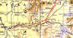
In the 1860s, gold was discovered in Kootenay, British Columbia, and near Missoula in western Montana. This brought a constant flow of miners through this area. Many came from California. They would travel by boat from San Francisco to Wallula on the Columbia River near Walla Walla, Washington Territory. From there, they would access the Mullan Road and travel north to Spokane Valley and then head east. The road crossed the river near present day Plante's Ferry Park, where Antoine Plante operated a ferry. From there, it continued along the north side of the river towards Idaho. The distance was shorter, however, to follow the south side of the river and cross further east. Mullan chose the longer route to take advantage of the existing ferry. The river business was a good one and this brought entrepreneurs into the area.
Near the eastern boundary of present-day Liberty Lake was the town of Spokane Bridge. Long before a bridge was built, Chief Quinemose operated a profitable river crossing business at this location. In 1864, Tim Lee, Joe Herring and Ned Jordan built the first bridge on the Spokane River here. It was a toll bridge but because they were able to undercut Plante's prices and the distance of travel was shorter, the ferry crossing went out of business. The bridge washed out multiple times over the years but was always replaced by either the same or different operator.
In 1862, aided by the South's succession from the Union, Congress passed the Pacific Railroad Act. The first transcontinental railroad was completed in 1869 going from Council Bluffs, Iowa, to the San Francisco Bay in California. Though not a direct route, this helped settle the Spokane Valley, as pioneers would travel the same way as those California miners did by boat and then the Mullan Road. Then in 1883, former President Ulysses S. Grant drove the final spike at Scenic, Washington, completing the Northern Pacific Railroad from Saint Paul, Minn., to the Puget Sound. The Northern Pacific, which ran on the north side of the river through Spokane Valley, was the first practical way to reach the Inland Northwest and was a boon to the settlement. In 1892, another transcontinental railroad, the Great Northern, reached the area, and Spokane became a railroad hub.
With two major railroads in place, regional and local railroads were built to service the growing need. In 1907, an electric railway connected Spokane to Liberty Lake, Coeur d'Alene and Hayden Lake and regional resorts were under way. Liberty Lake Park was so successful, it became known as "Spokane's Inland Seashore."
As automobiles became popular and affordable, more and improved roads were built. The primary route from Spokane to Liberty Lake was Sprague/Appleway avenues. In 1925, Congress passed an act to standardize the naming of highways. This route to Liberty Lake became part of Highway 10. In the 1950s, construction on the Spokane Valley Freeway began. Eventually, all the local roads of the Highway 10 system were replaced by sections of freeway forming Interstate 90. Today I-90 is the nation's longest interstate, covering more than 3,000 miles from Seattle to Boston.
Ross Schneidmiller is president of the Liberty Lake Historical Society and a lifetime resident of the community. Members of the LLHS research and write a monthly history article for The Splash.